
It feels like a long time since I wrote my blog – you’d think that lockdown would be a good time to write, all that time on your hands – but somehow I felt constrained by the constraints. Now, in March 2021, with the prospect of the restrictions being lifted, I feel like getting going again.
Two things have happened over recent months.
Number one – it rained. A heck of a lot. Through the winter, the chalk aquifer filled up; the water table rose. The River Ver flowed through Markyate!
But only sometimes….
Watching the flow readings in the village from the gauge provided by the Environment Agency (EA) there were occasional rushes of water through, implying that the EA were controlling the water flow at the sluice just above the village.

A big lake formed above the sluice, in Cell Park.
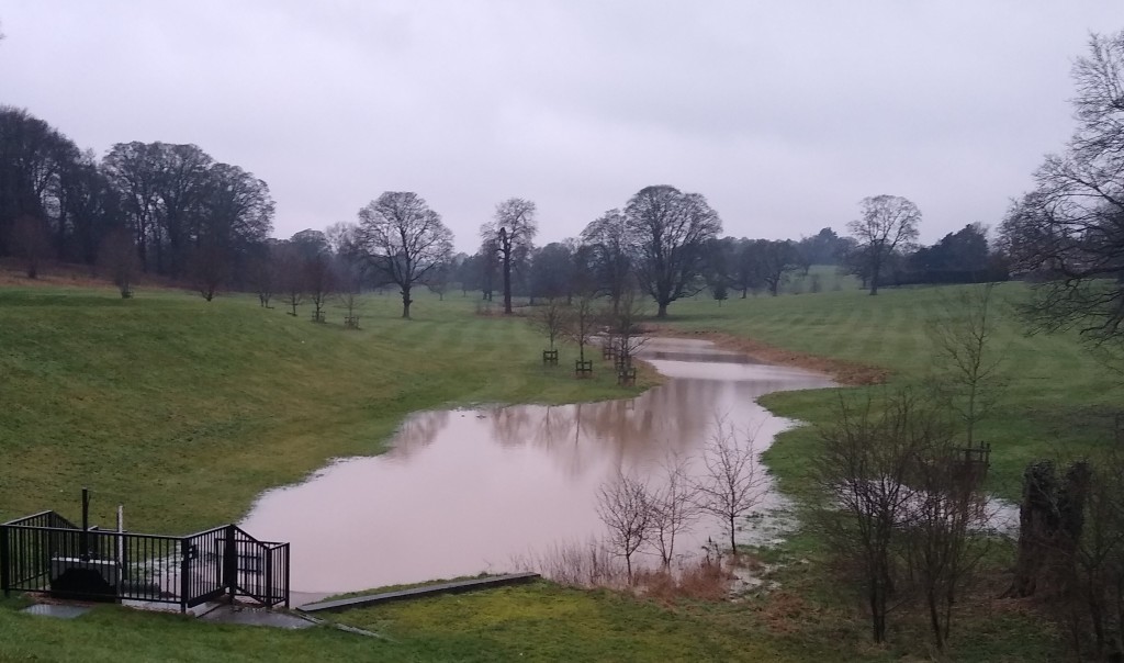
But, except for occasional road runoff from the A5, upstream from the lake the river course was…dry.

So, on January 31st 2021, there was no flow at the official ‘source’.
(As an aside, there is a growing movement about the pollution caused by road runoff – interesting talk hosted by the Chalk Aquifer Alliance…https://chalkaquiferalliance.wordpress.com/talk-archive/ for a talk by Jo Bradley from the Stormwater Shepherds)
Number two thing that has happened recently – I discovered a new bird survey that I hadn’t heard about – the Waterways Breeding Bird Survey (WBBS).
This is run by the British Trust for Ornithology (BTO) – they run loads of fascinating surveys (https://www.bto.org/our-science/projects) The BTO is a bit like the RSPB but more sciencey.
I have been doing a normal Breeding Bird Survey (BBS) for the BTO for years in local woods and fields but the WBBS is different in that it surveys birds along rivers and canals – basically the same sort of thing but wetter.
Aha I thought! Wonder if they are asking for surveyors along the River Ver! Sadly, it appeared not…but there WAS an available survey area along the Grand Union Canal between Berkhamsted and Hemel Hempstead.
Well, canals aren’t chalk streams, the habitat I’m interested in mostly – however, in this area the canal runs right alongside the River Bulbourne chalk stream, in the next-but-one valley over to the Ver – you could say that canal and stream are intimately connected, sharing water several times along the way.
So, this first week in March, on a very cold, foggy morning, I walked the possible route. Such a contrast, to be in a watery valley, very different from the dry hilltops of the Chilterns where I live and farm. I saw Grey Wagtail, heard Cetti’s Warbler – and was that a Chiffchaff? And, yup, I was hooked.


My new project combines 2 of the old projects – namely, birds and chalk streams.
My chalk stream project has been expanded into the neighbouring valleys – along with the River Ver, the River Bulbourne – and while I’m at it, the river in the valley in between, the River Gade – all flow into the Colne before they flow into the Thames.
Here’s a couple of maps:

And….zoomed in on ‘my’ bit….the Bulbourne is the unmarked fork south of the Gade.

Note how close the River Lee is – but it’s not connected at all to ‘my bit’ and flows into the Thames by a completely different route…Also note what poor condition the chalk streams are in….sigh….
And, since you’ve asked – here’s a map of the whole of the River Thames basin…

My plan is to go and have a look at the source of these 3 streams – Ver, Gade and Bulbourne – in the next few days, while the water table is still high – this is my best chance to see some action there.
Coming out of lockdown….getting things going again….
p.s. I realise there are no sandwiches in this post – very sorry….
