More Cathedrals – Winchester and Salisbury

Two cathedrals in one weekend!

Friday 12th January 2024 – Winchester Cathedral

When I arrived at the cathedral there was a great deal of preparation going on for a very special event that was happening the next day – a service of welcome to the new Bishop of Winchester, Philip Mounstephen. The Perpendicular Gothic nave looked stunning, with beautiful flower arrangements:

Winchester is the longest Gothic church in Europe; it is dedicated to several Saints, most notably St Swithun.

The transepts and tower are Norman – this is the north transept.

We had a guided tour which pointed out many items of interest:

From left to right: the font, made from a block of Tournai marble, moved into the centre of the cathedral by Medieval builders and never returned to the west door; a page from the Winchester Bible; and Jane Austen’s grave.

From left to right: The memorial to William Walker, the diver who worked for 6 years taking tons of cement underwater to strengthen the foundations; the Pilgrim Steps – you must start on your right foot and end on your right foot if you want to get to Heaven; and coffins in the retrochoir – the bones have been removed for carbon-dating.

++++++++++++++++++++++++++++++++++++++++++++++++++++++++++

We spent the night at a converted coach house airBnB in Broughton, halfway between Winchester and Salisbury. Had a really good pub meal then watched The Traitors.

Saturday 13th January 2024 – Salisbury Cathedral

You can’t help but be impressed by Salisbury cathedral – you can see the spire (Britain’s tallest) from miles around, every direction. It’s absolutely magnificent. The West Front is pretty cool too…

This cathedral was built in 38 years (1220- 1258) and is all in the Gothic architectural style and most of it is Early English Gothic. The spire and tower were added later (1310-30). There is a lot of Purbeck marble in the pillars – this was the fashion – the 12 cathedrals built at the same time all make use of it.

We actually had THREE tours in Salisbury – the first was of the medieval clock - made in about 1386 and probably the oldest working mechanical clock in existence. After that we managed a quick visit to see the Magna Carta….

…before rushing off on the second tour around the body of the cathedral, and then a TWO HOUR tour up the tower to the base of the spire.

We saw the memorial to Edward Heath, who used to live in Cathedral Close and has given his house to the nation; the magnificent font, in the centre of the nave; and a dipstick for testing the water level under the cathedral – at the moment it’s only 2 feet down – it should be 4….it hasn’t flooded since 1915…

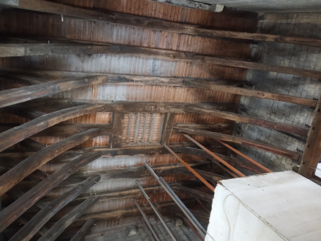
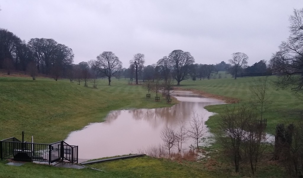
Up the tower we saw all the wonderful structural medieval oak timbers and had very wet views over the water meadows :

And, scariest of all, we ascended a steep and open spiral staircase to view the inside of the spire – the photo on the left is looking straight up the inside:

The photo on the right shows a wheel that the workers used to rotate by walking it to lift the building materials up to the top of the spire. We learned that Christopher Wren was involved in building the spire and it is nearly a metre out of true.

And some random facts: you can tell which stained glass is medieval as it has little black dots on it; Salisbury has only got 4 bells- there were originally 10 – so there is no peal of bells – it’s the only cathedral without a peal. There is no screen in the nave, so you can see from one end to the other; the East Window is dedicated to Prisoners of Conscience. The original cathedral was at Old Sarum, two miles away on an exposed hilltop.

We both really really liked Salisbury Cathedral and wonder, although we’ve said all along that you can’t have the prefect cathedral, whether Salisbury is going to be our favourite.

+++++++++++++++++++++++++++++++++++++++++++++++++++++++++

One fact I learned this weekend are – there are 42 cathedrals in England! In other words – lots more than I realised!! Like – there’s one in Portsmouth….I didn’t know that…my cathedral book has lead me astray…this needs more research obviously…

++++++++++++++++++++++++++++++++++++++++++++++++++++++++++

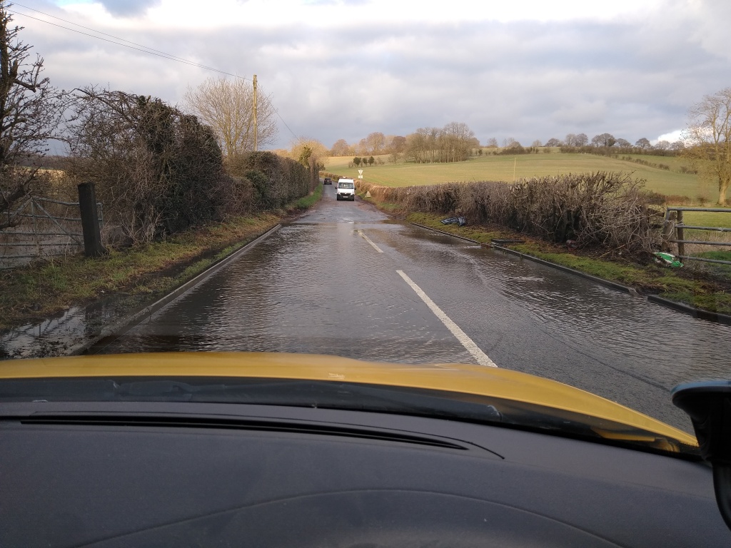
I spent the rest of the weekend visiting an old school friend, driving through a bit of the New Forest (who knew there were DONKEYS running loose there!) then walking and bird-watching at Keyhaven Marshes. It was a beautiful sunny, calm day and the tide was REALLY HIGH! Roads were getting flooded, and the saltmarsh was underwater.

I saw 47 species of bird – the highlights were: seeing the Brent Geese on the flooded saltmarsh – look at them all!; seeing SO MANY Common Snipe, out in the open, not hiding away like they usually do, and sitting in the bird hide beautifully run by Milford-on-Sea conservation volunteers with my sausage ciabatta and coffee – heaven.

+++++++++++++++++++++++++++++++++++++++++++++++++++++++++++

Sue goes to Cathedrals – St Albans, Ely, Wells and Gloucester

Slight change in subject matter!

A new project, with my friend Gill, to visit Cathedrals – in England to start with, but who knows where this may take us….

This blog isn’t meant to be a historical or architectural guide – just a pleasant reminder of our visits. I recommend the book The Cathedrals of England by Alec Clifton-Taylor published by Taylor Hudson if you want more information.

Here is a map of the English cathedrals from that book:

Off we go!

ST.ALBANS CATHEDRAL – visited November 21st 2022

Our natural first choice – Gill and I grew up in neighbouring villages near to St.Albans – and Gill went to school there. We called it the Abbey then. Containing the shrine of St. Alban, it has the longest nave of the English cathedrals.

Much of the outside is made from Roman bricks, from the remains of Verulamium, and local flints. A pair of Peregrine Falcons were perched on the tower in the sunshine.

We saw a brilliant light show which showed how the medieval murals would have looked when they were first created.

The magnificent interior arches are distinctly Norman:

We had lunch in the restaurant and couldn’t wait to visit our next cathedral!

ELY CATHEDRAL – visited February 13th 2023

We started to really get ourselves organised now. Ely was a bit far for a day trip so we sourced a local B and B for the weekend.

Ely, founded by St Etheldreda, has a beautiful Norman nave, but an incomplete, rather lop-sided west front with only one tower.

We booked ourselves onto a tour of Ely’s magnificent Octagon tower. It was stunning to look far over the countryside, and to peek out the wooden panels painted with angels onto the cathedral floor below.

An amazing 13-metre long table created from a 5000 year-old fossilised black oak discovered in the Fens was on display in the cathedral:

We had lunch in the town….

and relaxed in the B and B for one night then my grand-daughter Emily came and stayed with me for a night:

I also visited RSPB Ouse Washes which was really flooded. Great views of the cathedral on the Isle of Ely across the flooded ground…

There is a stained glass museum at Ely cathedral. It was closed while Gill and I were there, but I managed to pay a quick visit with Emily:

WELLS CATHEDRAL – visited April 6th 2023

Gill now lives near Bath, so invited me to stay the night before we visited the cathedral at Wells. Dedicated to St Andrew the Apostle, the stupendous West Front has far more original sculpture then any other English cathedral.

Again we booked a tour, up into the roof, to get a magnificent view of the structure.

The beautiful nave is Early English Gothic. The ‘scissor’ arches were inserted in the 14th century with great ingenuity to support the weight of the central tower.

We saw the clock striking:

Our visit to Wells was shorter than we would’ve liked – Gill got involved with giving her son a lift to the airport, and I miscalculated my parking ticket time – we resolved to COME HERE AGAIN! and really do it justice.

I decided to extend my little trip with a visit to the WWT reserve at Steart Marshes in Somerset.

GLOUCESTER CATHEDRAL – visited October 7th 2023

Again I stayed with Gill who is only an hour from Gloucester. We had a lovely pub supper then sat up much too late getting absolutely absorbed in a jigsaw…we know how to live….

Dedicated to St Peter, Gloucester cathedral has a magnificent tower – 225 feet high. We booked a tour to climb up it – Gill had hurt her leg and wasn’t sure she’d be able to manage the stairs but, trooper that she is, she got to the top. Apparently coming down was harder than going up though…

Sturdy Norman columns in the nave….

…exquisite fan-vaulting in the cloisters:

It’s largely passed me by, but I think there is some Harry Potter relevance to these cloisters???

Great Peter is the largest medieval bell in Britain, weighing nearly 3 tons.

Again I had decided to extend my little holiday and spent a couple of nights on the Gwent Levels to visit the RSPB reserve there. I stayed in a yurt in someone’s back garden!

+++++++++++++++++++++++++++++++++++++++++++++++++++++++++++

Bailiffing on the River Ver

I’ve been doing my river bailiffing once a month for 2 years now – the last time I wrote about it was October 2020. (To find out more about the bailiffing job, go to the June and July 2020 blogs)

The main reason I haven’t written since then is that we discovered that Markyate Sewage Works had been using the river to dump excess, nearly raw, sewage whenever they were overwhelmed. There were sanitary products in the water meadows and sewage fungus was growing in the river. It was all very depressing and I really didn’t feel like writing about it.

We started testing the water with a phosphate meter and found the levels were very high, so, as part of my bailiffing role with the Ver Valley Society, I have taken on the job of doing monthly phosphate tests to monitor the pollution at 5 sites of the upper reaches of the river. So we can get a fuller picture of the problem. It’s not what I thought I was going to be doing when I took on the bailiffing role! But I’m pleased to be helping, getting the figures, so when we have talks with Thames Water we have some stats behind us.

The Ver is not alone – many many rivers in the UK are grossly polluted, as you probably have learned from the media coverage. And we can’t just blame the Sewage Works – phosphate leaches into the river from other sources such as agriculture…and then there’s the road runoff too….it’s not a pretty, or a straightforward picture.

So forgive me if this report isn’t so upbeat as previous blogs….

It sounds so idyllic – walking along the route of the Ver chalk stream- and in some of the lower stretches it is a very pleasant experience. But, through Markyate, except in times of high rainfall, when a surge of road runoff becomes a stream, or when the water table is high, there is no water where the river is supposed to go….

This state of affairs continues out of the village until you get to the sewage works – that’s where the head of the stream is. You can see the outfall – the black pipe on the far left of the photo on the left.

You can see the sewage fungus more clearly in the photo on the right- it looks like green filamentous algae…

This, then, is my first sampling point. Here is my sampling kit:

(That’s not a reading on the phosphate tester; it’s just counting down the 3 minutes you need to wait until the chemical reaction is finished.)

You take a small water sample, take a reading of that in the green tester then add a reagent to it, mix it for 2 minutes before replacing it in the tester which then waits another 3 minutes till it takes a second reading.

Here is the actual reading of the phosphate level at the sewage water treatment outfall:

Yeah, I know, I got the month wrong…

And, to show it wasn’t a one-off, here’s the reading from a few hundred yards further downstream:

The reading is supposed to be under 0.1 ppm….

We joined in with the Thames Water Blitz run by Earthwatch in Autumn 2021 which confirmed our figures.

After taking my readings, I walked along the main road by the river – another depressing experience….

Before turning off onto a side road into the hills with a feeling of relief…

I headed for the Ver Valley Society bench to enjoy my elevenses and was very pleased to find there my fellow Bailiff (and boss – she co-ordinates us all…), Mel. She was treating the beautiful bench with its map of the course of the river with some varnish (or something). So we sat on the grass, had a good old natter and took a few photos in the sunshine…

I felt a whole lot better when I set off for home a bit later….

I walked through a Chiltern bluebell wood which had grown some fantastic happy additions – brilliant for local children to play in…

In the weak sunshine I could hear a few birds singing – a Wren, a Great Tit, a Chaffinch – the Spring is not yet entirely silent….

********************************

Ver Valley Society webpage: https://www.riverver.co.uk/

Chalk Aquifer Alliance, supporting local groups like the VVS: https://chalkaquiferalliance.wordpress.com/

Three chalk streams – finding the sources

I’m ashamed to say, this blog is not what it was.

How it started – leaving the car at home, using bike or public transport, and sandwiches, every time;

How it’s going – driving everywhere and not a crumb of sustenance.

I have excuses for the car – living in the sticks, no public transport…yadda yadda….but to go out without sandwiches – that’s not how I was brought up to behave – things have got to change.

*********************************************************

In my last blog ‘Chalk streams a go go’ in March 2021, I got it in my head to go and find the sources of my three local chalk streams – as it had been such a wet winter there were high hopes that the sources would be evident, running, and exciting to see!

So, I give you, in the north corner, the RIVER VER, followed by, in the south corner, the RIVER BULBOURNE and lastly the RIVER GADE, in the middle corner. Maps and stuff are in the March 2021 post.

Beginning with undoubtedly the best – the RIVER VER – my home stream, the one I care for. Unfortunately, visiting the source is not an exciting experience. It is always dry. But here for the sake of completeness, is a photo of the Source of the River Ver during this very wet winter:

Not at all wet.

Moving swiftly on….

Second chalk stream – the RIVER BULBOURNE. This is a river I am only just beginning to explore – I am starting a bird survey here this Spring and, although it shares a lot of its length with the Grand Union Canal, it is in places quite clear and chalk streamy. Here’s an information board about it:

So this board says that the Bulbourne rises ‘near Cow Roast’; Wikipedia says it starts at ‘between Dudswell and Cow Roast’, the OS map looks like this:

I parked the car in Dudswell and walked up the Grand Union Canal. There were tantalising glimpses of the river on the other side of the canal:

On reaching Cow Roast, I crossed over the bridge and did a U-turn, walking back along the main road. No sign of the river, only a garage with a ditch, but then a layby and a path into a rough area of scrub and grassland.

Naturally, I took the path, and eventually came upon the most marvellous sight of a field in flood – a water meadow and the source of the River Bulbourne. In the winter sun, it looked quite beautiful.

I plotted my position on Google maps – the source was definitely further north than shown on the OS map (and on Google maps).

Buoyed up by my success I decided to try my luck at finding the source of my third river, the RIVER GADE.

This river has been a central part of my life – when my children were little, everything revolved around the villages in the Gade valley- Great Gaddesden where the Church was, Little Gaddesden where the school was and Gaddesden Row, where home was. We crossed the course of the Gade at Hudnall Corner every morning on the route to school – and we hardly EVER saw it flowing.

The source of the River Gade is marked on the OS maps thus, very near Valley Farm:

Motoring down the main road I decided to pull in at Mile Barn Farm to have a recce. There was a path down inside the hedge which I took – and found this:

Crikey! I seemed to have stumbled across the start of the Gade, making a water meadow of a field where livestock were grazing. The next field was similarly flooded, so I drove down to Hudnall Corner and couldn’t believe my eyes…

Good Lord – water right across the road! With ‘flood’ signs, mud, failed road surface, tyre tracks on the verge – this had been going on a long time…never ever seen it like this before….

Water all over the place in the fields either side:

The Gade wins! Sorry, Ver, you came last. You’ve simply been completely outclassed. I know you can’t help it, and I will forgive you and make allowances for you.

********************************************************

In an attempt to make things right between me and the Ver we had a bailiffing session last week. To give her a chance I chose a different spot to do my flow test. It was a bit further downstream to where I used to go, and things are a lot happier there, as the vegetation is not too dense and the water burbles along much like a chalk stream should.

I did my flow test – a stick travelled 5 metres in 7 seconds; I measured the depth of the water – 38cm; and the width – about a metre. Full marks, Ver – you are a Good River.

Things at the new bailiffing spot are a bit busy with traffic, what with the main road and the truck stop, so it’s not really a sandwich-eating place. Which is a shame, because the stream here is actually very pretty, with clear water. I’m thinking there is a good place just a bit further upstream, where next month I can go and make my bailiffing a proper formal event, with sandwiches and everything. And we can properly make up.

Chalk streams a gogo

It feels like a long time since I wrote my blog – you’d think that lockdown would be a good time to write, all that time on your hands – but somehow I felt constrained by the constraints. Now, in March 2021, with the prospect of the restrictions being lifted, I feel like getting going again.

Two things have happened over recent months.

Number one – it rained. A heck of a lot. Through the winter, the chalk aquifer filled up; the water table rose. The River Ver flowed through Markyate!

But only sometimes….

Watching the flow readings in the village from the gauge provided by the Environment Agency (EA) there were occasional rushes of water through, implying that the EA were controlling the water flow at the sluice just above the village.

A big lake formed above the sluice, in Cell Park.

But, except for occasional road runoff from the A5, upstream from the lake the river course was…dry.

So, on January 31st 2021, there was no flow at the official ‘source’.

(As an aside, there is a growing movement about the pollution caused by road runoff – interesting talk hosted by the Chalk Aquifer Alliance…https://chalkaquiferalliance.wordpress.com/talk-archive/ for a talk by Jo Bradley from the Stormwater Shepherds)

Number two thing that has happened recently – I discovered a new bird survey that I hadn’t heard about – the Waterways Breeding Bird Survey (WBBS).

This is run by the British Trust for Ornithology (BTO) – they run loads of fascinating surveys (https://www.bto.org/our-science/projects) The BTO is a bit like the RSPB but more sciencey.

I have been doing a normal Breeding Bird Survey (BBS) for the BTO for years in local woods and fields but the WBBS is different in that it surveys birds along rivers and canals – basically the same sort of thing but wetter.

Aha I thought! Wonder if they are asking for surveyors along the River Ver! Sadly, it appeared not…but there WAS an available survey area along the Grand Union Canal between Berkhamsted and Hemel Hempstead.

Well, canals aren’t chalk streams, the habitat I’m interested in mostly – however, in this area the canal runs right alongside the River Bulbourne chalk stream, in the next-but-one valley over to the Ver – you could say that canal and stream are intimately connected, sharing water several times along the way.

So, this first week in March, on a very cold, foggy morning, I walked the possible route. Such a contrast, to be in a watery valley, very different from the dry hilltops of the Chilterns where I live and farm. I saw Grey Wagtail, heard Cetti’s Warbler – and was that a Chiffchaff? And, yup, I was hooked.

My new project combines 2 of the old projects – namely, birds and chalk streams.

My chalk stream project has been expanded into the neighbouring valleys – along with the River Ver, the River Bulbourne – and while I’m at it, the river in the valley in between, the River Gade – all flow into the Colne before they flow into the Thames.

Here’s a couple of maps:

And….zoomed in on ‘my’ bit….the Bulbourne is the unmarked fork south of the Gade.

Note how close the River Lee is – but it’s not connected at all to ‘my bit’ and flows into the Thames by a completely different route…Also note what poor condition the chalk streams are in….sigh….

And, since you’ve asked – here’s a map of the whole of the River Thames basin…

My plan is to go and have a look at the source of these 3 streams – Ver, Gade and Bulbourne – in the next few days, while the water table is still high – this is my best chance to see some action there.

Coming out of lockdown….getting things going again….

p.s. I realise there are no sandwiches in this post – very sorry….

A wet weekend

There was a heck of a lot of rain at the weekend. I made the mistake of forgetting to empty my rain gauge and it overflowed, so I can’t tell you exactly how much, but anecdotally there was ‘more than October’s usual monthly rainfall in just three days’.

So this morning, Monday, I decided to go and have a look at ‘my’ section of the River Ver and see how the river was coping with the deluge. (Quick update: over the 3 months of my bailiffing, there has been no flow at all – I’ve not been able to play Poohsticks and my corks are still in their little plastic bag. For an explanation, see July’s blog)

It was a pretty grim, dull morning when I set out and the Ver Valley looked grey and damp. Not much Autumn colour around to brighten things up either.

The Ver Valley Society bench was a welcome sight – note the soggy field behind…

I walked down the footpath towards the source of the river at Kensworth Lynch.

On reaching the source it looked like there had recently been a substantial water flow, but all that remained was a puddle. I now wished I’d walked out the previous day, when I might have caught more action….

Further downstream, at Red Cow cottages, again there were signs of water, and a few wet patches, but no flow.

Same story in Markyate although, amazingly, in places the river bed looked totally dry:

I followed the course of the river downstream alongside the A5 till I got to my bailiffing HQ at River Hill, Flamstead, where I measure the flow (or not) once a month. Surprise, surprise, no flow there either. But hurray! the sun came out and I had a pleasant ten minutes eating my elevenses….for once, not a sandwich, but an avocado…listening to a Red Kite calling from a nearby Oak tree.

Just before where the A5 meets Junction 9 of the M1 the river goes under the road – this is where you usually start to get an actual flow. And, hurray, there it was again….not very fast, and not much of it, but a relief to actually see some clear water on the move.

Approaching the motorway junction the fields were flooded…

At this point the river water gets swollen with heavily polluted runoff from the road complex.

In complete contrast to scenes on the Upper Ver, this is what it looked like further downstream, at Redbounbury….

….and in St Albans, over the weekend.

The upper reaches of the River Ver struggle to achieve a flow as the groundwater level is too low so any rainfall quickly gets soaked up. A major cause of the low level is excessive abstraction from the chalk aquifer by the water companies and others .

READ ALL ABOUT IT! on the Ver Valley Society webpage https://www.riverver.co.uk/

The Chalk Aquifer Alliance (https://chalkaquiferalliance.wordpress.com/) brings together groups campaigning for their local chalk streams.

Junction 9 marks the end of my bailiffing stretch, so I climbed back into the hills to make my way home.

The Ver Valley looked quite different in the sunshine from the dull views I’d had that morning. In a stubble field I counted forty Skylarks, rising from all around my feet, singing loudly.

Here’s my route, all 10 miles of it. https://www.strava.com/activities/4154108206

First day being a Water Bailiff

Two empty days in lockdown, what to do with myself?

FIRST EMPTY LOCKDOWN DAY

I decided to have a look at Kensworth Lynch, at the source of the River Ver, the chalk stream in Hertfordshire I am bailiffing. We’d had a wettish week and I wondered if there was any sort of a flow there.  I now have my own rain gauge (£4.99 impulse buy at the local garden centre – it’s not a complicated device) and I’d logged 24mm (about an inch) of precipitation over the previous 7 days. I’m interested to compare my measurements with those of our nearest weather station at Rothamsted Research, 7 miles away to the south-east, at 130m above sea level– I live at 165m. Of course they have proper instruments, costing rather more than £4.99. I expect their recording system is a bit more sophisticated than mine too…

Ruby the dog and I set off on a damp grey afternoon, tramping along farm tracks and footpaths by fields of nearly-ripe winter wheat and spring barley.

thumbnail (7)

Kensworth Lynch is only 2.5 miles from the dry hill where I live, a pleasant walk through undulating countryside down to the source at 143m. The route we took is on Strava at https://www.strava.com/activities/3737106459 with more photos.

I wasn’t surprised to find the river bed at the source was only just a bit damp – the upper reaches of the Ver are after all classed as a winterbourne, a river which only flows in the winter months when there is more rain. Ruby looked a little crestfallen though….

thumbnail (8)

A short distance away from the source is Kensworth pumping station.

thumbnailIt abstracts 6 million litres a day from the Ver aquifer, explaining in part the low level of the water table – with no abstraction, there would probably be a river where there should be one. The Ver Valley Society http://www.riverver.co.uk/  is campaigning to have this abstraction reduced or even stopped completely, so that our beautiful, rare and valuable chalk stream is restored.

But it doesn’t help of course that we all use too much water – yup, including me and you. Top of my to-do list – buy a water butt.

The return walk was a bit rainy but it was so mild we just got wet, hardy souls that we are, Ruby and me.

SECOND EMPTY LOCKDOWN DAY

It rained in the night – another 7mm. I had put a dustbin under the runoff from the caravan roof and it had NEARLY FILLED UP in the night! That’s about 90 litres! And I read somewhere (in the Affinity literature I think) that a Hertfordshire resident uses 200 litres a day on average. That’s over 2 dustbinfulls! OMG is, I think, an appropriate response.thumbnail (11)

I decided to go and start my bailiffing duties on the Ver. I am supposed to go once a month. I collected together the things I would need: my badge, my Bailiff’s Report sheet and my Notes for Guidance When Completing the Bailiff’s Report. I remembered I needed a stick for measuring depth, and my bag of corks which the previous bailiff had kindly given me.

For my measuring stick I found a pole from an old parasol and marked it off in centimetres – it served as quite a good walking pole and, being hollow, made a nice noise when I banged it down on the ground each step.

I set off via my allotment – here’s the route on Strava, with lots of photos https://www.strava.com/activities/3741188835

The site I am monitoring is on River Hill near Flamstead. It is just off the A5 but actually is fairly quiet and rural once you’re away from the main road.

The river course runs through pleasant meadows which I guess you would call water meadows…if there were any water….

thumbnail (20)

There were lots of bees and butterflies on the Burdock flowers…

At the place where the road goes over the river I looked through the fence. On both sides of the road I saw lots of vegetation, and just a little bit of water.

I got my measuring stick and found there was 18cm of water, plus 12 cm of mud. I measured the width of the channel and found it was 1.5 metres wide. I would send these measurements on my Bailiff’s form to the Bailiff co-ordinator so she could work out the amount of water flowing along the river.

And now the most exciting bit – I had to measure the rate of flow. This means dropping a cork into the river and timing how long it takes to travel 10 metres (basically under the road) – if you’re familiar with A A Milne’s books about Winnie the Pooh, it’s the equivalent of playing Poohsticks but with corks.

I carefully dropped my cork in the water. thumbnail (22)I set my stopwatch.

I got ready to run to the other side of the road.

After 3 minutes my cork had gone…absolutely nowhere. It was exactly where I’d dropped it in.

Basically there was no flow to measure.

I lay on my tummy and watched the water. It all looked very static, brown and uninteresting. Not really like a burbling chalk stream should look.

Then….a movement…wait a minute – something lives in this murky mess! A tiny froglet appeared, actually swimming about. Hurray for the froglet! Long live the froglet! I abandoned my flow monitoring with some hope in my heart.

I walked up River Hill to where the Ver Valley Society have put one of their wonderful benches. I sat there with my measuring stick, eating my Hummus and Chinese Leaf on Ciabatta sandwiches, watching the Swallows flying low and the Red Kites and the Easyjets flying high over the Spring Barley and thought about the ending of lockdown.

thumbnail (30)


Ref my previous blog, in June 2020, I have found out how big the watershed of the River Ver is – and where it is…it’s 132 sq.kms for the whole catchment, and 62 sq kms for the Upper Ver, north of Redbourn which includes ‘my bit’.

Screenshot (63)Also ref my previous blog – I’m still not sure about the difference between Giant Hogweed and normal Hogweed. I’m sure I will find out soon.

To find out more about this blog, go to https://sue6665.wordpress.com/about/

Bailiffing on the Ver

If you are baffled about this blog, please look at: https://sue6665.wordpress.com/about/

Part way through the lockdown for the Covid virus in Spring 2020, confined to base and feeling a bit aimless, I was approached by the Ver Valley Society. A vacancy had come up, they said, working in a voluntary capacity for the society as a Water Bailiff. They had a team of 12 bailiffs, each responsible for looking after a stretch of the river, taking flow readings and generally keeping an eye on things. Best bit was, the vacancy was in MY BIT!!! I replied, in UPPER CASE, with lots of exclamation marks, YES PLEASE!!!!

This was my dream project – I couldn’t believe my luck.  I’d only been a member of the Ver Valley Society for a few months but I’d really enjoyed walking the length of the river (see previous posts ‘A Celebration of Walking’), been to an interesting meeting called Have I got Poos For You, and met most of the committee, who seemed a pleasant bunch. And of course, it was all about the beautiful and rare chalk stream on my doorstep, where I grew up and where I live now.

After lockdown had eased slightly and we were allowed to meet people outside, observing social distancing, I had an induction ceremony, got a badge and a whole load of maps,

got shown how to measure the flow of the river at my monitoring point, River Hill in Flamstead (it involves playing Poohsticks with corks – now who can resist that…) then….. I was on my own….

First thing to do, of course, was recce the site of my bailiffing responsibilities.

My stretch (the pink line on the map) starts at the source of the river, near Kensworth Lynch, and ends at Friars Wash aka Junction 9 of the M1. The course of the river is very roughly about 4 miles long, although I’ve got no idea how big the actual watershed is.

route of my bit

I devised a 13-mile round route from my home:

Screenshot (60)

More detail and photos on Strava: https://www.strava.com/activities/3588207777

I set off on a pleasant June morning, in shorts and t-short, rucksack (with sandwiches of course!) on my back, whistling Roy Orbison’s ‘It’s Over’ (it’s easier to whistle that song than to sing it).

My first view of the Ver Valley, coming down off the heights of the Chiltern Hills was the area around Red Cow Cottages where Watling Street (now called the A5183)  follows the course of the river:

IMG_20200609_104240211

Continuing downhill I came to the source of the river, the area around Kensworth Lynch. The culvert at Corner Farm usually has a flow only after heavy rain – not today:

IMG_20200609_111141895

So, from here, it was downhill all the way.

The Kensworth Pumping Station is responsible for abstracting water from the River at this point- lots more information about the problems this causes and the attempts of the Ver Valley Society to get the EA and Affinity Water to reduce abstraction can be found here: http://www.riverver.co.uk/ Very important – there is an EA consultation about setting up River Basin Management Plans here: http://www.riverver.co.uk/please-respond-ea-consultation/  Please respond if you can! 

IMG_20200609_114430509

The next stretch of the River Ver runs alongside the A5183, in front of Red Cow Cottages where there is a little bit of road run-off in the riverbed….

IMG_20200609_115256785

before it disappears into the grounds of the Cell Park (note to self – try and get permission from the landowners to investigate this bit!) where there is (sometimes) a huge lake which has a dam with a sluice at one end to prevent flooding Markyate. No river here; risk of flooding remote…..

IMG_20200609_121535756

Through Markyate it’s the same old story – river bed, but no river….

IMG_20200609_124432074

Shame – the little bridges show that the houses have been built with a river in mind…..

The next feature along the course is Markyate Sewage Treatment Works:IMG_20200609_130205587

After this very noisy and busy stretch I was rather relieved to reach River Hill, the Poohsticks site near Flamstead:

IMG_20200609_135444406

It felt tranquil even though the main road was only yards away. This stretch needs a closer look – another landowner to get permission from …

IMG_20200609_131727960 I sat and ate my sandwiches – ciabatta rolls with cheese and tomato…IMG_20200609_132322887
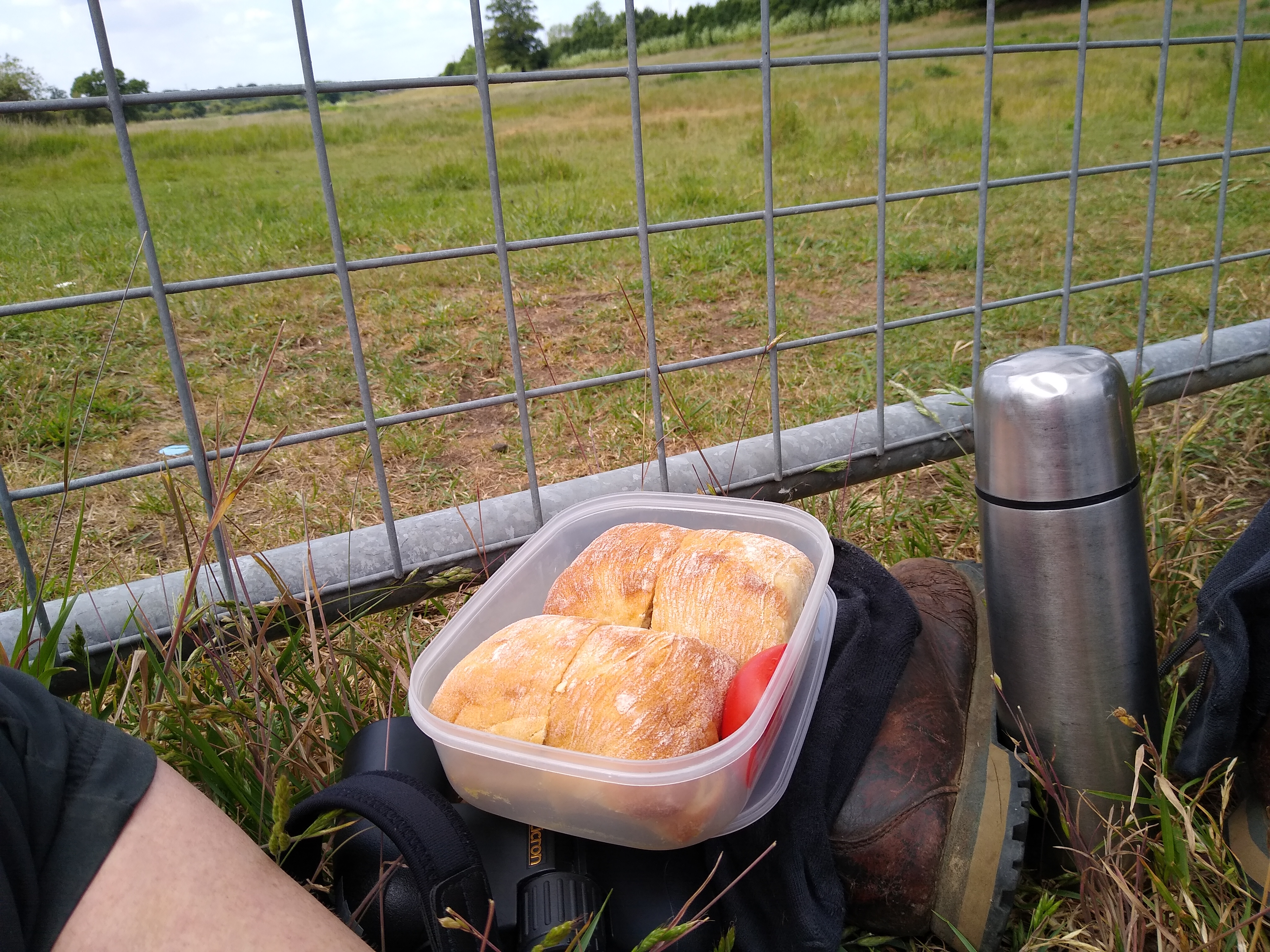
..and, the highlight of my day, watched families of Rooks (the adults were still feeding the youngsters) actually bathing in the river water. Here at last there was a little bit of water, although no flow to speak of, lots of silt and no life in the water that I could see.  But I also saw a Grey Heron in the river so maybe he had his eye on his lunch too.  IMG_20200609_131609670

From here the river travels through land belonging to Majestic Trees, who, being once again open to the public, very kindly allowed me to walk along the watercourse – as long as I donned a hi-viz jacket – they have lots of machinery moving around the site. Although there was still not much flow to be seen, it was good to see some water in the river, with lots of vegetation.

IMG_20200609_141718705

After leaving the Majestic site the river flows into a pond behind the old Chequers pub which is completely choked with plants – including massive amounts of two invasive species – Giant Hogweed* and Himalayan Balsam. Invasive or not, the bees were enjoying the Balsam! *I may well have got my Hogweeds muddled up and what I saw was just the normal (very big) Hogweed and not the invasive giant sort – apologies! Will research and report back…..

IMG_20200609_144103764

I’d reached Friar’s Wash at Junction 9 of the M1 – the end of my stretch of the River Ver- where there is another pumping station:

IMG_20200609_144823531

…and another testament to the presence of the river:

IMG_20200609_144733250

From here I headed back up into the hills and back home, feeling a bit depressed (a river with no water…)  and stressed (so much traffic and noise, pollution and litter) and wondering whether I’d drawn the short straw (further downstream, in Redbourn and St Albans the bailiffs actually have water in their river!) but still enthusiastic about ‘my’ stretch  – this is where the effort is needed; this is where we could see great results from curbing excessive extraction – this could be a brilliant chalk stream to enhance the lives of so many local people, and massively increase the biodiversity of the area.

I did make a count of the birds I saw – along the actual course of the river I saw  27 species: Greater Spotted Woodpecker, Wren, Woodpigeon, Blackbird, Chaffinch, Robin, Blue Tit, Stock Dove, Blackcap, Dunnock, Crow, Buzzard, Song Thrush, Goldcrest, Red-Legged Partridge, Coal Tit, Jackdaw, Pied Wagtail, ROOKS, Great Tit, Grey Heron,  Magpie, Pheasant, Yellowhammer, Swallow, Goldfinch, Long-Tailed Tit.

In the wider valley I also noted 6 more species: Kestrel, Whitethroat, Chiffchaff, Starling, House Sparrow, Starling.

Here are some seasonal wildflowers:

Momentarily stumped….

Looking back on this post in years to come I’ll maybe struggle to recall why I was ‘momentarily stumped’ – then remember, and reflect on how Covid19 was such an over-riding concern for all of us.

And looking back on my previous post – it’s hard to recollect the upbeat joyousness of my plans for the summer! Just to quickly run through them….

Run 5k – hah! Even 6k – double hah!! My body said no – specifically my KNEES said no. Ankle (once broken) was fine and uncomplaining, but as a result of the pain in my knees I decided to settle for a future without running. Move on.

Walk the Ver from south to north – as with so many events, this one is postponed til 2021.

I am Green Challenge-less! I am Project-less! For the next weeks and months I’ll get through lockdown and whatever the virus flings at us as best I can, like all of us.

But as this blog is all about Green Challenges and not about Covid19 Challenges, for the minute I’m signing off…but…. I’ll be back 🙂

In case you’re missing the photos of me with my picnic…here’s me with a hummus and coleslaw sandwich yesterday….

And here’s photos of my two little cuties, sent to me this morning….


Celebration of Walking 4

The last Celebration of Walking! I have walked the length of the River Ver! In 4 sections, so not such a great CHALLENGE as it’s not the longest of rivers, but more of a CELEBRATION – of being able to walk again after breaking my ankle, and of the natural world, rivers in particular, and our own little chalk stream in this neck of the woods, West Hertfordshire.  Also, most importantly, a  celebration of the pleasure to be found discovering places without using a car – by foot, bike or public transport.

For my next little walking project, I am wondering about walking the whole route again – but the other way ie south to north, with the sun at my back, from the end to the source, AND, to make it more of a challenge, doing it all in one go. What a delightful way to spend a long Spring day. Shall start the research!

I have also decided to have a go at proving that I have regained the power to run – I can’t bear the idea that I have lost the ability to…. run for a bus, run across a road, run to help someone in peril, run to put out a fire, run back indoors when I’ve forgotten my keys…..so I’ve downloaded the Couch to 5k app and am aiming to use it to train myself up over 9 weeks to run in the Redbourn Fun Run on May 3rd – hopefully I’ll get good enough to enter the 5k distance. I’m on my second week of training, so I’ve made a start. I have actually run a 5k before – when I was 55, so what I would REALLY like to do, now I’m 66, is run 6k. Well, it makes sense, doesn’t it? Haha.

Back to the walking.

Today was the by far the sunniest day I’ve had for this challenge. I caught the 34 bus to St Albans and walked down Cottonmill Lane to rejoin the Ver. Here’s my route:

Celebration 4 route

For more info and photos –  https://www.strava.com/activities/3147757051

The river was looking beautiful and flowing really strongly after all the rain we’ve had recently:

IMG_20200302_100602597_HDR

Walking through Sopwell Nunnery Green Space was a soggy business – the river had burst its banks in several places:

I found myself lingering in this area – it was quite beautiful – in the grounds of Sopwell Nunnery and the little Local Nature Reserve:

I was reminded how successful urban wildlife areas could become. I sat on a very handy, wonderfully dry, bench provided by the Ver Valley Society and had my elevenses. Along this stretch I heard and saw a good variety and number of birds – brought out by the sunshine no doubt, but the most I’d seen so far along the river.

A long stretch of the river passes through extensive water meadows – I was enjoying myself through this section so much I deviated from the path and found myself cut off by flood water. I was tempted to take off my boots and paddle but in the end I retraced my footsteps. It was extremely soggy….

….and muddy….

But after the mud came the beauty:

IMG_20200302_122722481_HDR

I was getting close to the finishing point, the confluence with the Colne:

IMG_20200302_124313782_HDR

Still one major barrier though….the M25…..

IMG_20200302_130527945_HDR

After a bit more walking the noise from the motorway had died down a bit so I sat and ate my chicken and cucumber on sour dough rye bread sandwiches by a peaceful stretch of the river and felt a bit sad that soon it would all be over.

IMG_20200302_132032271_HDR

But the end, at the meeting of the two rivers was so spectacular! Both rushing along, both bursting their banks, flooding the whole area. This is the actual meeting point – the Ver is coming in behind the massive fallen tree to meet the Colne:

IMG_20200302_134438399_HDR

After the confluence there was such a huge swell of water – it was really exciting to see.

I was actually a bit worried about falling in and getting swept away….

IMG_20200302_134606378

It will be so interesting to go back in a few months’ time and see it in a different mood…

Going home time – I made my way to Bricket Wood station and caught a train back on the tiny line that goes into St Albans Abbey station. The ticket machines weren’t working and nobody was around to sell me a ticket so….I didn’t buy one!

IMG_20200302_140655623_HDR

After catching the 34 bus back home it was the end of my journey, the end of my Celebration of Walking.

Today I walked about 8 miles, and the map on my wall is complete:

the route

I came a cropper with my bird-watching app and lost all my records so no list this time 😦

For more information about the Green Challenges:                          https://sue6665.wordpress.com/about